Knauss legislative fellowships in Congress help build careers — and they're fun and educational. See our video and fact sheet for details.
Blue Crab Travels: Studying Tags Offers Insights into Crab Habitats and Dispersal
If you caught a blue crab on the Chesapeake Bay during the past year or so, you might have seen one with a pink plastic tag attached to its shell. I’m part of a scientific research team who asked fishers and watermen to report those tags, and I am glad to report that those calls and e-mails are contributing to a better understanding of the Bay’s blue-crab population and how to sustain it.
The tags were part of a scientific study I was involved in to improve knowledge about where adult male crabs travel in the Bay. In summer 2015 I wrote on this blog about the efforts that my lab and I went through to organize and undertake this large-scale crab tagging experiment. Since then, I and the other members of the Fish and Invertebrate Ecology Lab (a.k.a. “The Crab Lab”), at the Smithsonian Environmental Research Center, have completed our work to release the tagged crabs tagging efforts across Maryland, with 8,741 adult blue crabs tagged in total. As expected, it meant a lot of early mornings with a few pinched fingers along the way.
It is the largest study of its kind to focus on the movements of adult male crabs in Maryland, and I’ve been very pleased with the level of public involvement. The tags displayed information asking people who caught a tagged crab to report it by phone or online. So far from our calculations, it looks like over 78% of people who caught a tagged crab reported it. (This figure combines the number of reported tags and my estimate, using a well-established mathematical method, of how many additional tagged crabs that were caught weren't reported.) Since the tagged crabs were released a year ago, you, the recreational and commercial crabbers of Maryland, have caught and reported 2,034 tagged crabs. I have the fortunate position of looking through this data and seeing what it means for the blue crab population.
 |
|
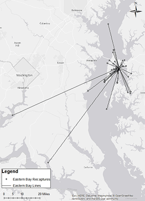
This map shows locations around the Chesapeake Bay where tagged crabs released in Eastern Bay (center dot) were recaptured. Eastern Bay was one of more than a dozen release sites used in my research study. Credit: Robert Semmler |
My study looks at the difference between where in the Chesapeake Bay the tagged crabs were initially released and where they were recaptured later by fishers, in order to describe the movements of adult crabs over the course of the fishing season. These movements can be small, such as crabs caught a few meters from where they were released, or they can cover long ranges, as in the case of a handful of female crabs we released in the Bay that were (much to my surprise) caught in the sounds of North Carolina.
This work will help to identify important movement patterns that connect the shallow nursery habitats where juvenile crabs mature, such as in submerged aquatic vegetation beds, woody debris, and marsh edges, to the areas where adults are harvested. If you’ve ever been out fishing for blue crabs and pulled one from the water, you may have already had plans for it. Whether it's going for sale at the docks, coming home to your kitchen table, or just returning to the water after you take a few pictures of it, we often have a good idea of where the crabs we catch are headed next. But we often know little about where they came from.
My study seeks to shed light on the crabs’ movement by identifying where in the Bay the crabs caught in each tributary (specifically, in each official harvest reporting area) came from initially. With this information, I can identify important habitats that may contribute many crabs to commercial harvest zones and that should be preserved to optimize the economic value they provide to the fishery. For example, roughly 44% of the crabs we released in the Magothy River were recaptured in other harvest areas, including the Bay mainstem (38%) and the Patapsco (6%) and South Rivers (1%). After I complete this analysis this fall, my work will be presented to the Chesapeake Bay Stock Assessment Committee for their consideration and use. This panel, comprised of scientists and officials, annually considers data on blue crab harvests and population and advises the Maryland and Virginia state governments on how to sustainably manage the blue crab fishery.
An end goal of this project is to produce regional maps that can tell fishers where crabs in their local tributaries or harvest areas originally came from. By giving the public these and other bits of information about the movement of crabs, it’s my hope to increase stewardship of the habitats that make the biggest contribution to the health and sustainability of the fishery. Hopefully, with concerted efforts to improve water quality and restore the nursery habitats crabs thrive in, the Bay will have a robust, sustainable fishery for long into the future.
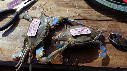
Photo, top left: Two adult male crabs tagged by SERC researchers in the summer of 2015. Credit: Kim Richie
See all posts to the Fellowship Experiences blog
Program Announcements
Featured Fellow
Leone Yisrael is a cephalopod-loving scuba diver, cook, and loves to try new activities. She conducts genetic analysis and fieldwork at the Smithsonian Environmental Research Center through the Coastal Disease Ecology Lab.
FELLOWSHIP EXPERIENCES ARCHIVE
FELLOWSHIP EXPERIENCES TOPICS
Related Products

The Blue Crab: Callinectes sapidus
An essential resource for researchers, students, and managers, this book is the first comprehensive reference work on the blue crab, Callinectes sapidus.
The blue crab is a significant U.S. commercial and recreational species from…