Knauss legislative fellowships in Congress help build careers — and they're fun and educational. See our video and fact sheet for details.
Faster Computers, Better Data Key to Predicting Storm Surges Better
Storm surge is one of the most dangerous natural hazards in America, and it happens frequently. Just a few months ago, Hurricane Matthew generated significant storm surges from Florida to North Carolina, which caused extensive flooding and damage in coastal communities along its path.
To protect Maryland’s people from potential future storm surges, my advisor Professor Ming Li and I are currently working on a project to improve storm surge forecast for the Chesapeake Bay. Our goal is to build up a system that can tell people in a timely manner precisely when and where the storm surge will happen and how high it can be.
But before we started our research, we needed to know what was the track record of storm-surge forecasting in the Chesapeake Bay. How good were storm-surge forecasts for the Chesapeake Bay in recent decades? We found that forecasts for storm surges during Hurricane Isabel (2003) and Superstorm Sandy (2012) were not very accurate. The National Hurricane Center underestimated by 20 percent the surge height in the Chesapeake Bay during Isabel. And nobody was able to predict that Crisfield in Somerset County would be badly flooded during Sandy.
We wanted to build and improve on the forecasting work of other scientists before us. But first we found we had to overcome some technical challenges.
We found several reasons why the earlier forecasts were less successful. Generally, in the storm-surge forecast, we need an atmospheric model to predict an approaching storm’s wind (speed and direction) and an ocean model to calculate storm surge forced by the wind. In the past, however, forecasters could only use rather unsophisticated atmospheric models. These models were run on computers that were not as powerful as ones are today. And the earlier models had to be simple – otherwise, the computers of that time would have taken too long to generate forecast data that could be shared with the public quickly enough before the storm to provide useful advance warnings.
 |
|
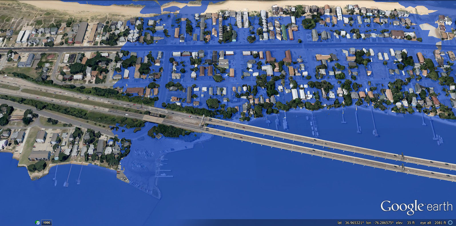
Inundation “hindcast” for Baltimore City during Hurricane Isabel (2003). Map data: Google, image compilation: Fan Zhang |
As a result, the earlier models’ forecasts for the wind, which is the primary factor determining storm-surge height, were not accurate enough.
Another reason for the models’ shortcomings in accuracy was that scientists lacked detailed-enough data about the land and surrounding water in coastal communities like Crisfield. Accurate forecasts require small-scale details about the ground elevation of such places and the bathymetry (underwater topography) of the Bay’s bottom nearby. Instead, earlier models represented the whole town and its adjacent water with just a few large, coarse-resolution squares on a map.
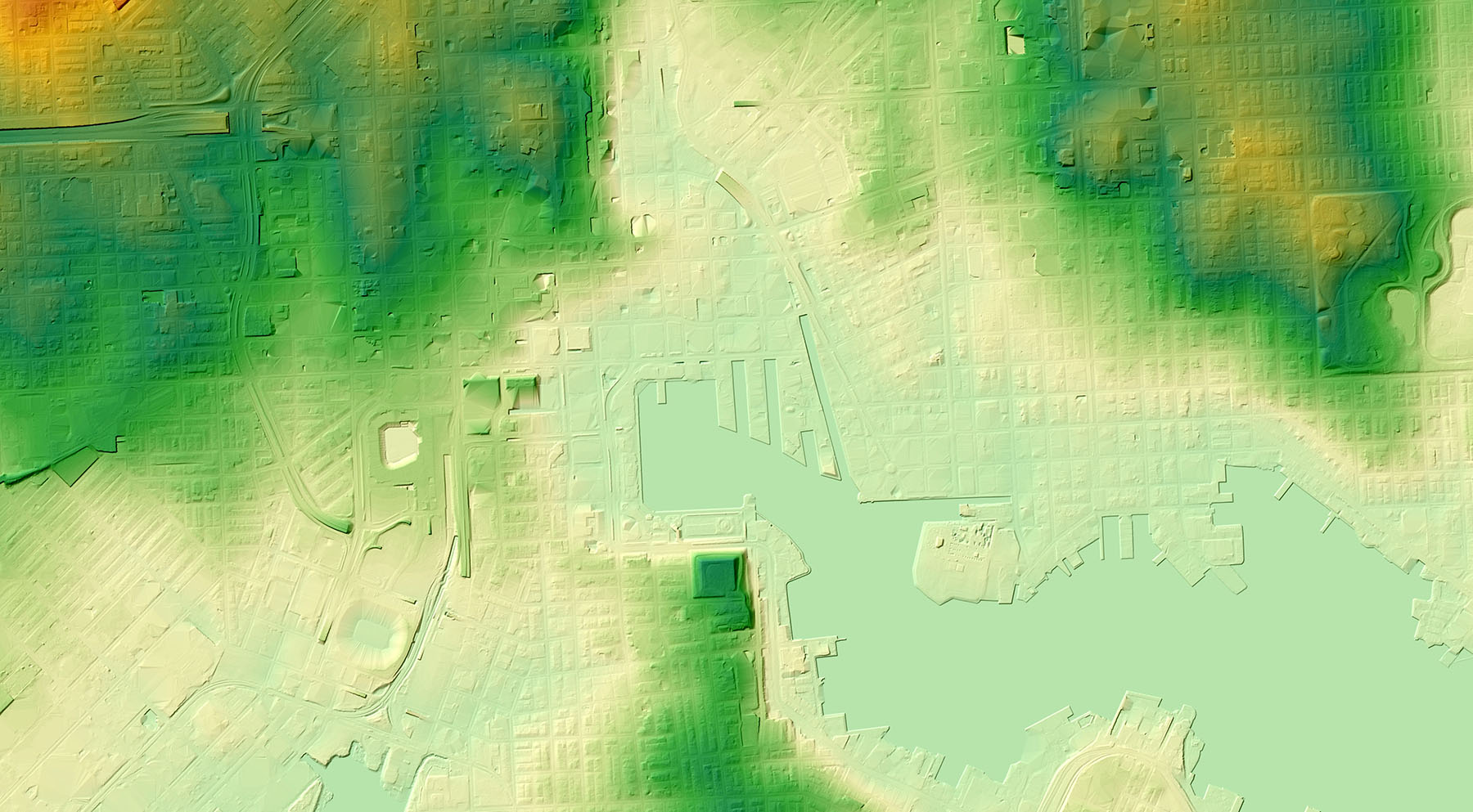
Can we solve these issues, Ming and I asked ourselves? Luckily, we found that a newly developed atmospheric model, the Weather Research and Forecasting Model, offers a good balance between speed and accuracy. In addition, we are finally able to use one of the world’s most advanced supercomputers, named Yellowstone, which was built in 2012 and designed for research in earth system science. We also found datasets showing elevations in every county in Maryland with ultra-high resolution (as fine as 2.5 feet square). These data, which we obtained from a state government website, gave us detailed information about every local creek of the Chesapeake Bay. Bingo, computer and data problems solved!
The next step in our project was to build a prototype of our storm-surge forecast system for Baltimore City. One of the most challenging parts was to generate ultra-fine-resolution grids to represent coastal features including small creeks in the ocean model. The only available grid-generating software, the Surface-water Modeling System, created grids for our situation that made the Finite Volume Coastal Ocean Model easy to crash. So we had to spend weeks making manual adjustments on these grids before we got the ocean model to work reliably.
But the work was worth it. We tested how well this prototype would have predicted the storm surge that was actually measured in Baltimore City during Hurricane Isabel in 2003. We were so excited to see that this “hindcast” perfectly matched the surge actually observed.
Encouraged by this success, we will expand the surge forecast system for the whole Chesapeake Bay. And we and other scientists will continue working to improve the accuracy of the models that enable the forecasts. We wish our efforts will make Maryland a safer place!
Photo, top left: Ultra-high-resolution elevation data for Baltimore City. Darker green and orange indicate higher elevations. Click on the image to expand it. Credit: Fan Zhang
See all posts to the Fellowship Experiences blog