Knauss legislative fellowships in Congress help build careers — and they're fun and educational. See our video and fact sheet for details.
Modeling Erosion in Chesapeake Bay: Waves, Sediment, and Seagrass
Living on the Eastern Shore of the Chesapeake Bay and studying the Bay’s environment for three years has enhanced my respect for not only the power of science but also the complexity of Mother Nature.
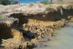
I often see wind-generated waves and shoreline erosion on the Choptank River, one of the Chesapeake’s tributaries. As an estuarine physical oceanographer, I luckily have the chance to study wave processes and their influence on shoreline erosion and sediment transport.
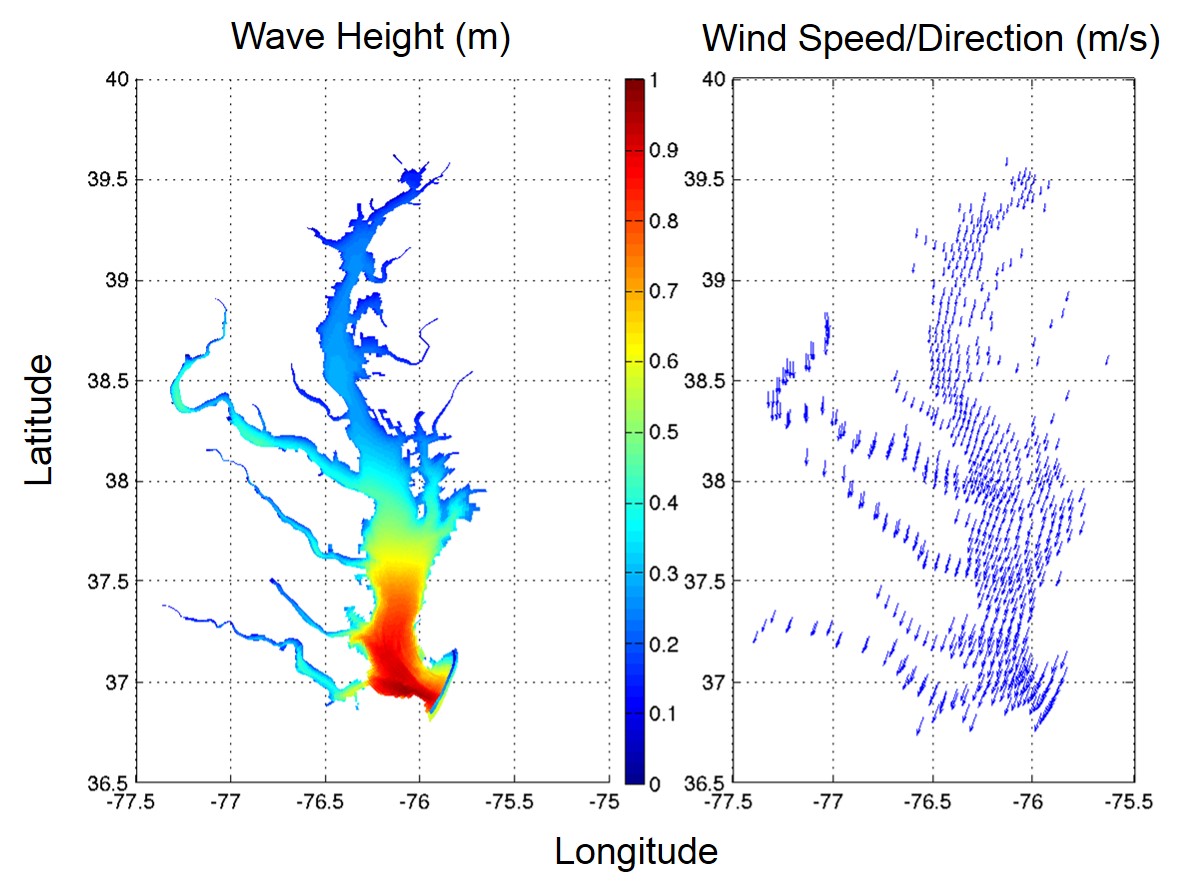
Even though erosion caused by sea level rise has drawn more attention, scientists know that wave power is the major factor for creating erosion in the Chesapeake Bay. My professor and I are exploring both of these factors that cause erosion and their influence on nearshore morphology (the shape of the coastline). We build numerical simulations for wave power covering the Bay’s entire shoreline so we can compare and correlate wave power with the historical erosion rate.
Our work to improve understanding of wave-induced erosion and sediment transport patterns may help to improve engineers’ designs of shoreline protection projects. Today, the major methods of controlling erosion in the Bay rely on artificial infrastructure, such as sea walls, breakwaters, riprap, etc. In the past few decades, these man-made structures have become more efficient at controlling erosion while minimizing disturbance of the local ecosystem. The design most widely acknowledged as environmentally friendly design is the "living shoreline." This design requires building a small, hardened structure (e.g., a breakwater) in front of a shoreline to attenuate bigger waves. In addition, marshes are planted at the intertidal zone to "kill" smaller waves and promote sedimentation (the depositing of sediment that can build up shorelines.) The complexity of local environments requires customized designs and selections of different combinations of structures and plantings -- and these designs can be refined through improved understanding of erosion and sedimentation.
As a Sea Grant fellow, I have also had the honor to explore the role of the extensive beds of submersed aquatic vegetation (SAV) that seasonally occupy the Susquehanna Flats in modulating the extra inputs of sediments and nutrients from Susquehanna River. The Conowingo Dam, which is located at the mouth of Susquehanna River, has historically trapped a significant portion of the sediments and nutrients. However, the trapping capacity of the dam has been reached, so more of these materials are reaching the Bay than in the past, presenting the risk of reducing the Bay’s water quality.
We have made several hypotheses about the Susquehanna Flats' role in controlling sediments:
- The flats trap sediments during the growing season and release them after senescence in the fall. This introduces a lag in the input of sediment to the Bay that reduces environmental impacts.
- Large storms are critical to sedimentation on the Susquehanna Flats because of large sediment inputs, fast currents, and waves.
- The flats’ SAV beds damp surface waves and concentrate flow and material into the adjacent unvegetated channels.
We plan on visiting the Susquehanna Flats region before, during, and after the SAV growing season to investigate currents, waves, tides, and sediments. Preliminary data have been collected during 2013 and 2014 indicating that SAV on the flats can almost completely damp surface waves. Because waves are the largest factor contributing to sediment transport in shallow water, this feedback between SAV and wave damping may critically affect sediment transport processes on the flats. Thus, we will also build a high resolution wave model to simulate these effects.
Numerical modeling has become more prevalent in both academia and industry. It’s the most powerful tool for resolving problems that are impossible to observe or derive theoretically. I have been using a wave model because there is no historical wave record covering the entire shoreline of the Chesapeake Bay for a 21-year period, and it’s almost impossible to measure wave energy inside and outside of the SAV bed in all seasons.
Being able to explore new findings and apply knowledge to real life situations is the most amazing part of being a graduate student and a researcher. As a modeler, I mostly program on computers, hiding behind my desk and code, but I also get chances to go out for fieldwork in the summer. Seeing heavily eroded unprotected shoreline out in the field, I sincerely hope my research will help to improve shoreline protection designs in Chesapeake Bay and benefit the understanding of sediment patterns of SAV beds. More exploration is on its way…
Photo, top left: Shoreline erosion in the Chesapeake Bay. Credit: Larry Sanford.
See all posts to the Fellowship Experiences blog
