Knauss legislative fellowships in Congress help build careers — and they're fun and educational. See our video and fact sheet for details.
Workshop Convenes Drone Pilots and Researchers to Aid the Study of Marshes

On any normal day, buzzing noises emitting from the University of Maryland Unmanned Aircraft Systems Research and Operations Center (UROC) would be chalked up to the center’s business of drone research. But one day in August 2024 found the center and its hangar abuzz with conversations between dozens of scientists and drone operators. They came together at Maryland Sea Grant’s Coastal Geospatial Horizons Workshop to share experiences and information about using drones to monitor marshes and other coastal ecosystems.
Maryland Sea Grant’s Taryn Sudol led the workshop for 31 participants representing federal and state government, academia, and industry at UROC in Hollywood, Maryland. Sudol is coordinator for the Chesapeake Bay Sentinel Site Cooperative, a hub of researchers and land managers who collaborate on marsh health and sea level rise science. Recently, she picked up on a growing regional interest in using unmanned aircraft systems, or drones, in marsh research. Drone monitoring can reduce labor and collect data in hard-to-access areas like marshes and shorelines.
As applications for drone research grow, the Sentinel Site Cooperative identified a need for networking and start-up guidance for marsh researchers looking to use this technology in their scientific research. Equipment and software selection and costs can be challenging for new pilots. Projects may require different tools and licenses, and careful planning is important in every flight. Sudol envisioned a workshop that would help drone rookies learn from their peers and result in a collection of resources for drone operators throughout the Chesapeake Bay region.
“When researchers in the cooperative shared their quandaries and successes, we saw that this topic was worth expanding to the broader marsh management and research community,” Sudol says. “We realized that folks were eager to learn more about drones and that some specific questions could be best answered by peers. We needed to give folks time and space to connect and discuss.”
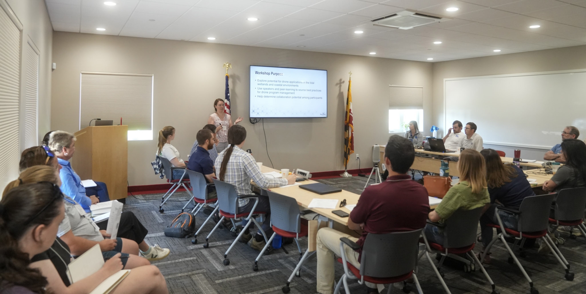
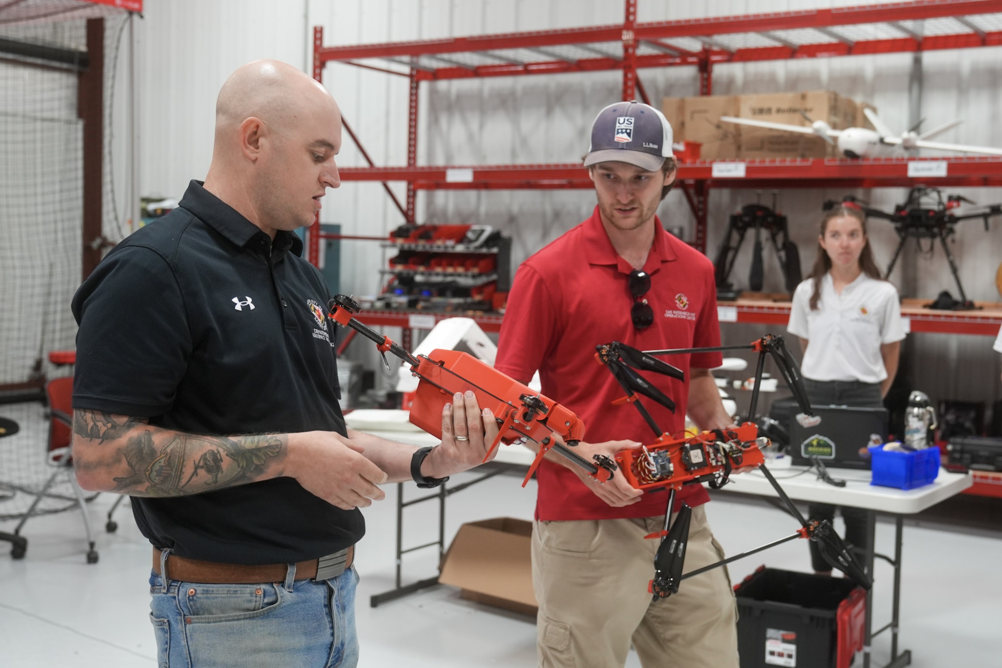
The Geospatial Horizons Workshop was designed with a morning of introductions, talks, and tours and an afternoon of discussion and brainstorming. UROC’s director, John Slaughter, presented about the center’s mission and function within the University of Maryland. The center works on a variety of drone research projects in topics as varied as precision agriculture, search-and-rescue, and medical delivery efforts. With the Patuxent River Naval Air Station as a neighbor, UROC receives a number of military commissions involving drones as well. Workshop participants toured the center’s hangar and heard from staff and student interns about some types of drones involved in their projects.
In the afternoon, Supriya Khadke, the Mid-Atlantic regional geospatial coordinator for the National Oceanic and Atmospheric Administration’s (NOAA) Office for Coastal Management, facilitated a discussion about drone data. Participants talked about ways to improve access to the data and imagery collected by drones. They also considered how drone data could be used for more than one research project.
Participants then launched into the afternoon’s peer-learning sessions. Dividing into groups, they discussed a series of prompts about applications for drones in marsh research and logistics for drone operations. UROC’s conference room thrummed with conversations about sensors, software, databases, federal drone policy, and flight logistics and planning.
Participants came to the workshop with varied levels of expertise, from basic interest to years of drone piloting experience, as well as a diversity of research interests. This made for active discussions and productive brainstorming. Workshop organizers collected information about how participants use drones in their research, significant considerations for those looking to begin monitoring marshes with drones, and other services that may help researchers use drones more effectively.
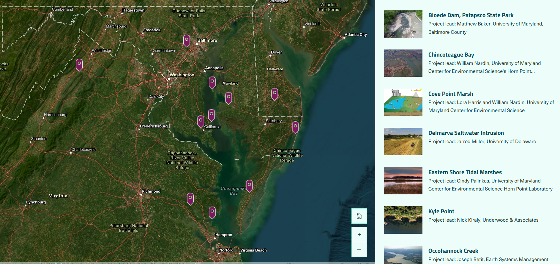
A recurring theme throughout the workshop was the value of networking and peer-learning in drone research. Drone projects are contextual, with project design depending largely on the site, variables, and data collection needs. The ability to discuss specific challenges with experienced peers was helpful to many. To promote further collaboration, Maryland Sea Grant created a Marsh Monitoring with Drones website with information about projects and researchers working with drones in the Chesapeake Bay area. Researchers and pilots may fill out a quick survey to have their information added to the webpage.
Sudol was pleased to observe the enthusiasm and problem-solving energy participants brought to the Coastal Geospatial Horizons Workshop. Participants came away with new connections, knowledge, field-tested tips, and inspiration.
“We can use drones in many ways to improve marsh research, monitoring, and management," says Sudol. "While there's still a lot to figure out, we know this group will continue to work toward the common goal of better understanding and supporting coastal ecosystems."
See all posts from the On the Bay blog
Program Announcements
News and Blogs


ON THE BAY - BLOG ARCHIVE
ON THE BAY - BLOG TOPICS
Featured Fellow
Leone Yisrael is a cephalopod-loving scuba diver, cook, and loves to try new activities. She conducts genetic analysis and fieldwork at the Smithsonian Environmental Research Center through the Coastal Disease Ecology Lab.
Featured Research Project
Developing a habitat model for mysids, an important link in Chesapeake Bay food webs
Mysids are important mesozooplankton prey for many species of fish in Chesapeake Bay and are an important link in transferring energy from lower to upper trophic levels. Mysids also serve as biological vectors for benthic-pelagic coupling due to their diel vertical migration and omnivorous prey-switching behavior, which makes mysids important regulators of food web architecture. Despite their central role in coastal food webs, surprisingly little is known about mysid ecology and dynamics in Chesapeake Bay.