Knauss legislative fellowships in Congress help build careers — and they're fun and educational. See our video and fact sheet for details.
Finding Common Ground on Deal Island
Scientists and Residents of a Small Community Try a New Way of Discussing Sea Level Rise
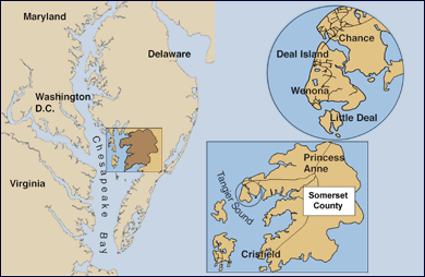
Deal Island may be the epitome of the slow pace of life on Maryland’s Eastern Shore. This isolated island and its nearby peninsula jut out into the Chesapeake Bay from Somerset County. It’s a quiet area ringed by green marsh grasses where only one road — Highway 363 — connects about 1,000 residents to the mainland. Here, watermen harvest crabs and oysters from the nearby Tangier Sound, and, as anthropologist Michael Paolisso puts it, life on the island still revolves around “the flow of working the water.”
But despite this rustic lifestyle, Deal Island residents are grappling with change: The commercial fishing industry in Maryland has been declining for decades, and many young people have left Deal Island for economic opportunities elsewhere. At the same time, sea levels around Deal Island, as along other locales on the Eastern Shore, are rising.
Responding to these changes has been the focus of an effort called the Deal Island Marsh and Community Project. The project is a long-term collaboration between scientists at the University of Maryland, state and federal government agencies, and leaders in the Deal Island community. Through a series of public meetings and other activities, the project team is working toward a simple-sounding goal: to get these same groups to talk about the changes occurring across the region.
That hasn’t always been an easy task. Throughout Maryland’s history, the relationship between members of the scientific community and residents of traditional commercial fishing towns like those on Deal Island have been spotty. The two groups have sparred over the best ways to manage the crab and oyster fisheries in the Bay. And they’ve disagreed over what is causing sea levels to climb around the estuary. The hope, however, is that if the scientists and Deal Islanders can learn to build mutual respect for each other, even if they don’t agree on every issue, they might be willing to work together in the future — to help the community here to prepare for sea level rise and other coming challenges.
The project puts this traditional region of Maryland front and center in an experiment that asks: is there a better way to handle conflicts over the environment? “I’m always amazed that once people get to know each other, they’re willing to let their differences be. It doesn’t mean that they get rid of them,” says Paolisso, a professor at the University of Maryland at College Park and one of the project’s leaders. “But they’re still willing to work [together].”
He Was In Control
Working together is the theme tonight in this spacious annex built next to St. Paul’s Church in Wenona, Maryland, at the tip of Deal Island. The hall is warm and brightly lit, and a group of about 50 people cluster together on folding chairs. There is a spread of sweet tea and cookies in the corner. The Rev. David Webster kicks off the night by leading the group in prayer. He talks in a deep voice and a thick Eastern Shore accent. Among other things, he asks that God “make our home a beautiful place to live.”
Webster, who grew up on the peninsula that abuts Deal Island, serves as pastor for the three Methodist churches in the island’s three communities: the towns of Chance, Deal Island, and Wenona. He’s also a waterman who started working on his father’s boat when he was six years old.
Tonight, the pastor is one of a handful of scheduled speakers at this meeting, organized as part of the Deal Island Marsh and Community Project. His audience is a mixed bunch: in attendance are several dozen locals who drove in from around the island and other nearby towns. There are also a handful of scientists listening, too, including representatives from the Maryland Department of Natural Resources.
The pastor doesn’t deny that sea levels are rising across the Eastern Shore. But, like many in this church hall, he doesn’t necessarily agree with scientists about what’s causing these changes — and what people can do to slow them down. Researchers attribute global sea level rise mainly to manmade climate change. Webster, however, says that he believes that it’s God, and not people, who ultimately controls what happens to the seas. During periods of environmental change, “He was in control,” Webster says.
Despite these differing views on the causes of sea level rise, the mood in the hall tonight is friendly and respectful. And that’s the whole point: the participants in the Deal Island project haven’t come here to debate or argue. Instead, they’ve come to learn from each other. Or, as Webster puts it in his talk, the goal is “to not look for ways to disagree with each other, but to look for common ground to stand on.”
.gif) |
| The Rev. David Webster, pastor of three churches that serve Deal Island, was among the local residents who participated in organized discussions about sea level rise. Credit: Sky Swanson |
This pursuit of common ground was launched in 2013 by Paolisso and Brian Needelman, a marsh ecologist at the University of Maryland at College Park. The duo received a nearly $600,000 grant for a two-year research effort from a state and federal partnership called the National Estuarine Research Reserve System (NERRS). The partnership operates a series of wetland reserves in Maryland, including one on Monie Bay on the Deal Island Peninsula. Much of the team’s funding went toward an effort to explore techniques for restoring marshes in and around that reserve.
But Paolisso and Needelman also used a portion of that grant money to host a series of 10 meetings on the island. Some of these have been large public forums, like the “community conversation” held at St. Paul’s Church. Others have been smaller gatherings of key leaders in the scientific and Deal Island communities. Here, the Deal Islanders and researchers alike have gotten the opportunity to share what they know about the island: what is the history of the region? How fast are sea levels in the Bay climbing up, and where are the sites that are most vulnerable to flooding? Participants in these meetings have also discussed values, delving into how people feel about the environment around them.
Needelman says that he’s learned a lot from these conversations. On Deal Island, he says, locals carry a treasure trove of knowledge about the region’s marshes, including how these grassy habitats help to shield houses here from flooding. Ask a Deal Islander about what happened when Hurricane Sandy passed near the Bay in 2012, and they’ll point out the spots where the water came up to the crab shanties.
“I wouldn’t want to step up on a big scale to see who knows more,” Needelman says. “But I don’t think that’s what it’s about.”
What it is about is using these learning opportunities to spur those involved to start working to help Deal Island prepare for the changes ahead.
Collaborating Learning
The techniques that Needelman and Paolisso are drawing from in their project come from a field called collaborative learning. It has its origins a long way from the Chesapeake Bay.
The field, in fact, emerged out of conflicts in the late 1980s and early 1990s over preserving forests in the Pacific Northwest for endangered northern spotted owls. Dubbed “the owl wars,” the issue pitted environmentalists, government agencies, and loggers against each other in sometimes nasty disputes. Scientists and government officials tried to reach out to the angry parties mostly using traditional measures — they gave talks at public meetings and elicited comments on various reports. In most cases, however, this outreach strategy left room for information to flow in only one direction: from the scientists to the public.
Steven Daniels, at the time an expert in conflicts over natural resources at Oregon State University, wasn’t convinced that it was working. “I would argue that it had sort of a ‘Field of Dreams’ notion: convene it, and they will agree,” says Daniels, who is now a professor at Utah State University. “There was just sort of a sense that if you do everything right, and you get all the parties there, and you set it up — all of a sudden, magic happens. I just didn’t have enough faith that that magic would happen.”
So along with his colleague Gregg Walker, Daniels developed a new way of trying to get the warring sides of the owl wars to cooperate. How the collaborative learning process works can vary, but the general philosophy is the same: people make decisions, say about how much they drive or whether or not they shore up their house against flooding, based on any number of different factors — their religious views, politics, or bank account balances, for instance. If scientists want to influence the decisions that people make, they need to do a lot more than just explain why their research says a particular action is a good idea. They also have to make an effort to understand, and respect, all those other values that go into making up your mind. It’s a lot less “Field of Dreams” and a lot more listening.
Michael Paolisso, the anthropologist from the University of Maryland, has spent much of his career trying to build that same sort of understanding. He’s conducted research around Deal Island on and off for about 15 years. His work has explored, among other things, the culture of the area's watermen and their attitudes toward fisheries regulations. A few years ago, Paolisso even bought a house near Chance. He goes there when he needs a quiet spot to work or just wants to go fishing. "It really is quite a nice little house," he says.
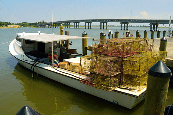 |
| A fishing boat near the bridge between Chance and Deal Island. Credit: Sky Swanson |
And he’s using this experience to help the scientists and residents involved in the Deal Island project come up with new ways of preserving the way of life in the region. The effort is the first to use the collaborative learning method to approach issues surrounding sea level rise on the Chesapeake.
In one day-long workshop held in February 2015, the anthropologist and his colleagues led about 30 scientific, government, and community leaders in a "pile sorting" exercise. All of the participants received a list of 12 features that make Deal Island vulnerable to change. They included things like rising seas and the isolation of the area’s communities. They were also handed a list of 11 resilience features -- or positive aspects of life in the region that could help Deal Islanders and their marshes to survive those changes. That might be the “ethic of cooperation” on the island, where locals say that neighbors help each other out in times of need.
The exercise raised some eyebrows. Many of the scientists present, for instance, said that one of the biggest vulnerabilities of the region was that the islanders “deny that they’re vulnerable,” says Katherine Johnson, a graduate student of Paolisso’s. In other words, locals don’t believe that the seas are rising.
Community members in attendance, however, were able to explain that they knew just how precarious their position was — they just didn’t know what they could do to change that. Through such learning experiences, “we can uncover an interaction like this, and we can actually have a discussion about it,” Johnson says.
Assigned Seats
Those interactions have begun to pay off, too, albeit in subtle ways.
Sasha Land heads up an effort called the Coastal Training Program, which is jointly managed by NERRS and the Maryland Department of Natural Resources (DNR). The program seeks to train Marylanders so that they can better tackle environmental issues, such as flooding and marsh loss. Land has been active in the Deal Island project since its inception. She says that she's noticed a small pattern that, to her, speaks of bigger results. When the project first began, she says, people attending meetings sat next to other people they knew. The state government folks sat next to state government folks and watermen next to watermen. Now, “we’re kind of more distributed than we were in the beginning,” Land says.
Of course, Paolisso says, there’s a big difference between getting along and actually getting down to business — in this case, helping to shore up Deal Island against sea level rise. But, he adds, the point of the effort was never to install sea walls or other flood control measures. Instead, it was to help build relationships that would last long after the project’s grant funding runs out in 2015.
"I think we've created a social group that is more resilient and more robust and flexible, that can address a number of issues in a very flexible way," Paolisso says. "To me that seems a lot more powerful than if we had just protected 100 feet of shoreline."
Needelman, the marsh ecologist, admits that these sorts of results are vastly different than what you’d expect from a traditional scientific study: where you start out with a clear goal and end with a set of findings that you can punch out in a research paper. “There’s a certain lack of comfort with that lack of clarity,” he says. But “I have this hope, maybe even some faith potentially, that by looking at this bigger picture and by integrating these larger questions, what we’re doing can have much more broad, meaningful, deeper, positive impacts.”
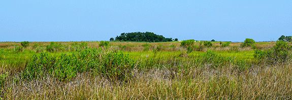 |
| Chesapeake Bay marshes, like this one on Deal Island, are threatened by the effects of sea level rise, which can increase the rates at which they erode. Credit: Sky Swanson |
He notes that collaborative learning projects like this one are probably too expensive to roll out across the Eastern Shore where numerous towns sit in the path of rising seas. But that doesn’t mean that scientists can’t still employ some of the fundamentals of this effort — such as a willingness to learn — when reaching out to Maryland residents to help them plan for the future.
On Deal Island, concrete plans are already beginning to emerge from Needelman and Paolisso’s social group. Land, for instance, is working with DNR to launch a “coastal resiliency assessment” of the region. Such an effort would employ satellite images and on-the-ground inspections to pinpoint areas of the island that are particularly at risk from flooding. Through conversations with Deal Islanders, the project team has already identified one area in particular that gets swamped every time a big storm rolls through. The group is exploring the possibility of building a living shoreline at that spot. That’s the name for flood control projects that use grassy plants to shield low-lying sites from crashing waves.
Andrew Webster is a resident of Chance who has attended several meetings through the project. He says that, in the end, it really doesn’t matter whether or not scientists and members of the Deal Island community agree about what’s causing sea level rise. They can still work together — up to a point. There doesn’t have to be a “lockstep, or close to it, agreement to a get a project moving like that,” Webster says. But “I think there has to be that acknowledgment and that dialogue between the sides … that we’re going to try to do what we can.”
David Webster, the minister, seems to take the uncertain future of Deal Island in stride. He refers to Methodist doctrine, which teaches that it’s God’s kingdom, and not the physical world as people see it, that lasts. Humans are only "temporary caretakers" of the planet, and of Deal Island.
"Everything in life is like that," he says. "You have to hold it in the palm of your hand gently because it's really not yours."
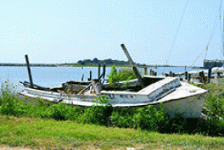
Photo, top left: A waterman retired this fishing boat by hauling it up on shore and leaving to decay, a not-uncommon practice around the Chesapeake Bay. Credit: Sky Swanson. Map illustration credit: Sandy Rodgers and iStockphoto.com/University of Texas Map Library.
For More Information
Deal Island Marsh and Community Project website
See all posts from the On the Bay blog
