Knauss legislative fellowships in Congress help build careers — and they're fun and educational. See our video and fact sheet for details.
Sentinels in the Sky: Observing rising waters from a birds-eye view

Some call it high tide flooding, others refer to it as sunny day flooding, while still others call it “king tide.” But no matter the name, we’ve seen the impacts of rising waters, which led to a recent flight where scientists and a journalist took to the air to document the water on the ground for the Chesapeake Bay Sentinel Site Cooperative.
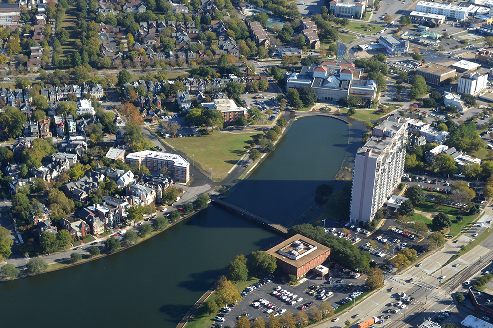
The Cooperative, which focuses on measuring water levels and marshes at key sites across the Bay, opted for boots in the sky on Oct. 28. From the air, the team looked at the flooding that NOAA predicted based on the lunar cycle and the Earth’s position around the sun. With an idea of when the tides were going to rise, the team planned to look at some sentinel sites in Virginia on the Eastern Shore, as well as around Norfolk and Gloucester, and Virginia Commonwealth University’s Rice Rivers Center.
On the plane were Scott Lerberg of the Chesapeake Bay National Estuarine Research Reserve of Virginia, Cora Johnston of the Virginia Coast Reserve Long Term Ecological Research Program, DelmarvaNow environmental reporter Julia Rentsch, and pilot Mary McCutcheon, of SouthWings, a nonprofit organization of volunteer pilots that fly over environmental hazards and endangered places to help highlight the need for their restoration and protection.
Chesapeake Bay Sentinel Site Coordinator Taryn Sudol posed some questions to the group about their involvement. Their responses have been edited for clarity.
A SouthWings flight flies over the Hampton Roads area during an extreme high tide event. Photo credit: Cora Johnston
Why did you want to participate in this flight?
Scott: For the past decade, or longer, I’ve spent a lot of time trying to better understand wetland vulnerability to long-term changes in water levels. Most of that work has occurred on the ground with a focus on our four marsh components part of the Chesapeake Bay National Estuarine Research Reserve of Virginia, which are situated along the salinity gradient of the York River estuary. This flight offered a unique opportunity to view and photograph these areas from a different perspective as well as visualize a high water event across different land uses in coastal Virginia, which I hope will provide me with new insights moving forward with our wetland work.
Cora: As a relatively new member of the Cooperative, I was eager to both share the story of our research site while also getting a chance to see how it compares to some of the partner sites. The flight provided a perspective for comparison that would be more difficult to appreciate from the ground. I know from the Cooperative’s data that marsh elevation and relative sea level rise vary across our network; this provided an opportunity to see what that looks like across the landscape. It also provided a route by which to share that perspective with Julia, who is positioned to share what we saw with the communities affected by those very landscapes.
Julia: I wanted to participate in the flight because it gave me an opportunity to collect photos and video that beautifully and effectively show the effects of sea level rise on local, relatable, salient locations to our readers. And, it allowed me to speak with researchers in real time as we flew to get their perspective on what we were seeing and what was important. My news outlet would never have been able to afford or coordinate such an experience without the help of SouthWings.
Mary: Planes and pilots both need to fly frequently. We all need to exercise our pistons. So when Maggi MacQuilliam Blomstrom of SouthWings asked me if I could take this flight I enthusiastically said “yes.” The big bonus was that we were going to see exceptionally high tides along a fragile coastline and to see firsthand what the rise in sea level combined with a king tide look like.
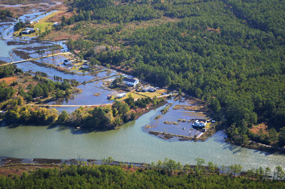
Many communities around the Bay are tied to inland towns by a single road. Photo credit: Scott Lerberg
What were you most surprised by or found most interesting during the flight?
Julia: I found it super interesting to see just how water-centric our area is. Obviously, the Norfolk and Newport News areas are communities with a long history related to the water, but to go up there and see the sheer amount of it winding through and around the cities is amazing. It is the dominant thing in your view at all times. Additionally, to see communities situated on outcroppings that may be accessible by just one road—to see the effects of a super high tide on their access to the mainland—really served to hit the issue home for me.
Mary: What I saw was astonishing. Islands that are on my aviation chart were simply not there at all, roadways were inundated and cars splashed their ways through, water was lapping at the back steps of homes built along the coastline. Knowing that this would only get worse in the future was sobering. I thought about the homeowners as well as the insurance companies. I thought about building codes and regulations and whether they would be effective.
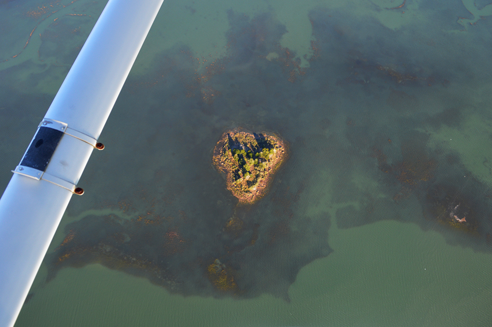
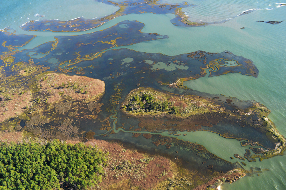
Cora: Our flight started over the seaside of Virginia’s Eastern Shore, where the completely flooded marshes were just stunning. We flew to see the biggest predicted tide of the year, but I was still stunned by how high the water was. I grew up exploring the marshes off of Wachapreague, and I navigate the seaside by boat weekly; the submerged marshes were wildly disorienting. The peninsula would look very different if our marshes were flooded more regularly. I was also intrigued to see how irregularly ghost forests are distributed across the landscape. As with any good observation, the flight brought up more questions than it answered. It accentuated how glad I am to be a partner in the Cooperative’s important work.
Scott: I was surprised by how much ground we could cover from the air. I thought we had requested a fairly ambitious flight plan trying to follow the high tide as it moved into areas of the Eastern Shore, the downtown Norfolk area, and then up the tributaries of the York and James River, but we had no trouble keeping up with the flooding event but were even a little ahead of the astronomical high tide when we reached the upriver areas of the York and James River. Some of the most interesting highlights of the flight were hearing Cora, who was born and raised on the Eastern Shore, not only be able to describe (anecdotally) how these flooding events impact the ecological, economic, and cultural aspects of the Eastern Shore, but to then be able to observe some of those impacts from the air. They include flooded piers making life for watermen more difficult, flooded farm fields impacting the farmland production, and understanding why institutions such as Virginia Institute of Marine Science have had to rebuild labs and offices to keep business running with increased high water events.
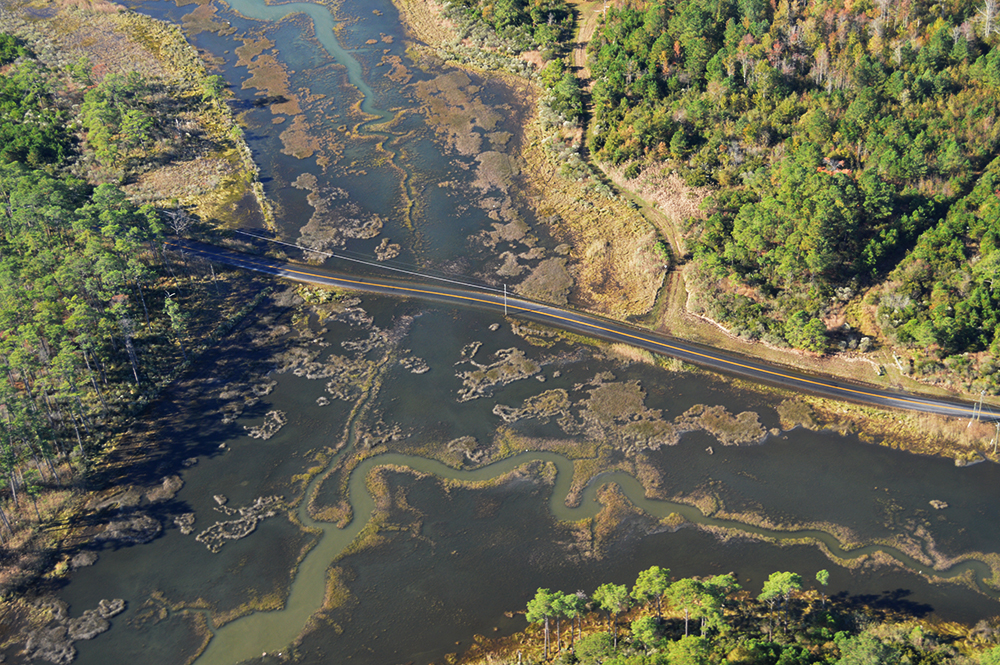
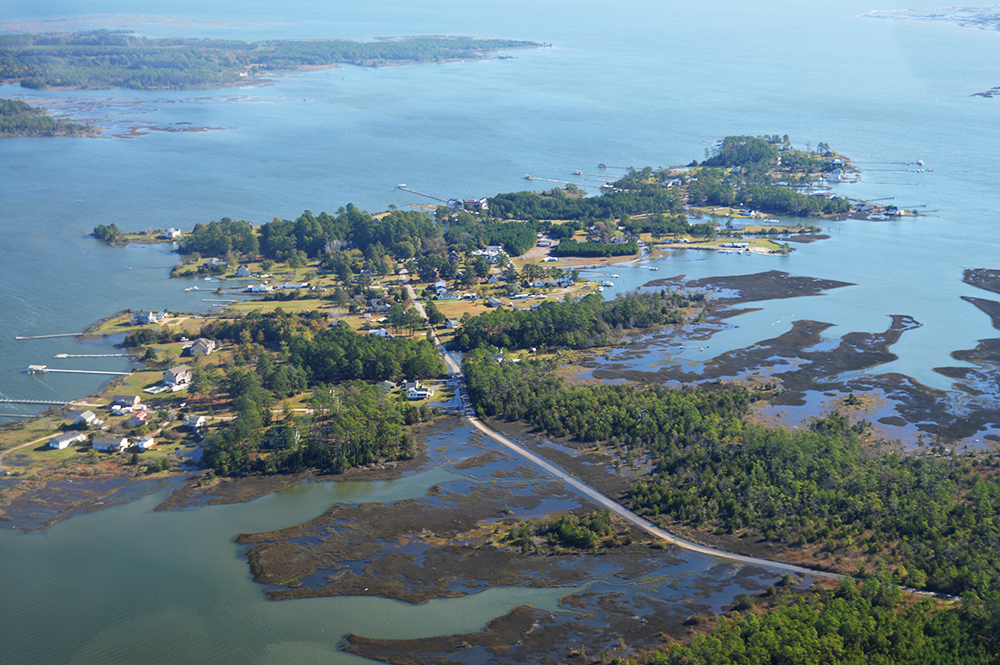
Roadway vulnerability to flooding. Photo credit: Scott Lerberg
What did this flight show you about high tide flooding in the lower Chesapeake Bay?
Cora: It became clear local impacts of flooding vary a lot based on elevation. Although the Eastern Shore is known for being low-lying, we could see that Norfolk and the Middle Peninsula are in the most immediate danger. This likely comes in part from more overlap between infrastructure and coastal waters. On the Eastern Shore, most of the coast is farm, forest, or small harbors. In the neighborhoods of Norfolk and Middle Peninsula (Gloucester Point and Guinea) we saw more flooded roads and property. From above, the inevitability of increased flooding becomes so much more obvious. We’d see a truck trudging through a salt water flooded road to houses or businesses out on necks and spits. From above, we could see how that flooding was slowly connecting small creeks and wetlands. It made us very worried about the future for many property owners in the area.
Scott: We have some issues ahead of us, both ecologically and economically. We witnessed in many areas, but particularly in the more rural areas such as the Guinea Marshes, road flooding that will impact people’s ability to get to their houses, or more importantly, the ability of emergency services to respond without challenges. The impact on the coastal forest community was also fairly dramatic, especially as we flew up the York River and above the Pamunkey River. We observed large patches of standing dead trees, also known as ghost trees, which became more and more prevalent upriver—a very good indicator of increased flooding as well as increased salinization of the upriver waters.
Only the highest elevations escape high tide flooding. Photo credit: Scott Lerberg
What’s one of your biggest concerns about sea level rise now and into the future?
Scott: The magnitude of the challenges which we are facing with regards to coastal flooding. Although there are local solutions, such as thin layer deposition to raise the elevation of a local marsh or installing a tide gate to protect a local town, the enormous potential cost and logistics of planning for sea level rise and increased flooding impacts on a regional or larger landscape scales seems daunting. There are also, as with many issues of today, the socioeconomic factors to consider and how folks with less resources and who might to be able to—or want to—move to another location will be able to do so. The challenges for the insurance industry appear daunting.
Cora: The need to share information is huge, as is the challenge of figuring out how to help residents see how the risk maps onto the landscape. Only then people can make informed decisions about their properties and lives. We still have a lot of work to do in the process of helping to turn our robust existing data into informed action across the region. As we saw in flight, better information and solutions are unlikely to become available as fast as some of lowest lying communities need it.
Significant infrastructure on the brink of flooding. Photo credit: Scott Lerberg
What gives you hope for the future of this region in light of the challenges it is facing?
Scott: The built-in resiliency of nature as well our ability to use—and mimic—this natural resiliency using nature-based features, such as living shorelines and management options such as thin layer deposition, to restore and protect some local habitats and communities in the short term. But the hope really comes in the people working each day to develop a better understanding of coastal flooding issues and come up with strategies to address the challenges of coastal flooding. The ability to contribute to this understanding and learn from others makes it rewarding to be a part of the Chesapeake Bay Sentinel Site Cooperative.
Cora: The cultural heritage of the Chesapeake region includes many signs of resilience; abandoned buildings and modified—now wild—landscapes show the signs of people who have retreated from water before, while maintaining their link to the region and a water-based way of life. In flight, we were also surprised by the vast expanses of open land just inland from the coastal communities where we saw flooding. Only a little way inland, we saw no obvious flooding. These signs gave us hope that our coast can absorb rising waters without acutely threatening the cultural heritage of the communities who live nearby.
Mary: We saw how entrepreneurs have created aquaculture plantations for clams—specifically Cherrystone clams. And we saw how there has been successful restoration of sea grass areas. I was heartened to see this and hungry for clams, which I will happily eat knowing that this is a sustainable seafood.
Aerial image of high tide marsh inundation. Photo credit: Scott Lerberg
What’s your favorite/least favorite thing about flying?
Julia: My favorite thing about flying is the exhilaration. Like our captain, Mary, said, exhilaration and happiness are closely linked! My least favorite thing about flying, especially in circles like we were, is the airsickness, especially in a small space! But a little nausea medicine and some ginger chews go a long way.
Scott: I generally enjoy flying but this was only my second opportunity to fly in a smaller Cessna aircraft flown by a very professional and engaging pilot, so it was just a wonderful opportunity to see so much of lower Virginia where I have spent the last few decades and travelled all over on the ground from an aerial perspective. My least favorite thing about flying in general is the hassle of short connections and delayed flights (i.e. the actual logistics of making each flight) but that wasn’t an issue for using this smaller aircraft where there is a real sense of freedom.
Cora: It provides a new perspective, which offers an excellent chance to see patterns and assess happenings with a fresh mind. Even though Scott and I were familiar with many of the landscapes we investigated, we were both surprised by what we saw from the air. It also helped level the conversation among those of us in flight; we were able to have a conversation based on a shared view and experience.
Photo, top left: Cora Johnston, Julia Rentsch, Mary MacMutcheon, and Scott Lerberg (from left to right) boarded a SouthWings plane to check out high tide flooding from the air. Photo, Maggi MacQuilliam Blomstrom
See all posts from the On the Bay blog
Program Announcements
News and Blogs


ON THE BAY - BLOG ARCHIVE
ON THE BAY - BLOG TOPICS
Featured Fellow
Leone Yisrael is a cephalopod-loving scuba diver, cook, and loves to try new activities. She conducts genetic analysis and fieldwork at the Smithsonian Environmental Research Center through the Coastal Disease Ecology Lab.
Featured Research Project
Developing a habitat model for mysids, an important link in Chesapeake Bay food webs
Mysids are important mesozooplankton prey for many species of fish in Chesapeake Bay and are an important link in transferring energy from lower to upper trophic levels. Mysids also serve as biological vectors for benthic-pelagic coupling due to their diel vertical migration and omnivorous prey-switching behavior, which makes mysids important regulators of food web architecture. Despite their central role in coastal food webs, surprisingly little is known about mysid ecology and dynamics in Chesapeake Bay.